Weather Forecasts for Safer, Smarter Flight Planning
Enhance routing, dispatch, and airport operations with high-resolution aviation weather data - including wind, visibility, icing, turbulence, and other critical parameters to support safe and efficient operations.

Weather-Aware Forecasts for Reliable Flight Planning
Integrate high-resolution forecasts, wind and turbulence insights, and atmospheric analysis into your planning workflow to optimise routes, improve fuel efficiency, and enhance operational safety with data-driven weather intelligence.
30+
Weather models provide a unique range of data
3,000+
Business Customers from more than 100 countries around the globe
250,000+
Weather stations enable world’s highest precision
Optimise Your Flight Operations with Precise Aviation Forecasts
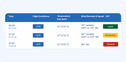
Aviation Specific Hazard Indicators
Beyond standard weather variables, meteoblue provides critical aviation risk assessments, including Clear Air Turbulence (CAT) intensity mapping to plan calm flight paths, in-flight icing risk at multiple altitudes, soaring index for thermal activity estimation, and boundary layer height impacting takeoff and landing.

Seamless API Integration for Flight Planning
All aviation weather data available through meteoblue APIs for integration into flight planning software, navigation apps, and aviation platforms. Standard REST APIs deliver data in CSV and JSON formats, images as PNG graphics for map overlay, and customisable parameters for specific use cases.
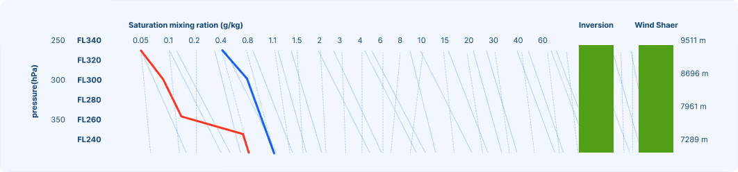
High-Resolution Models Across Flight Levels
Weather conditions change significantly with altitude. Our high-resolution models provide data from ground level up to 5'500 meters, including temperature, wind speed and direction, humidity, cloud layers, and aviation hazards at each flight level.
"What comes to my mind when I think of meteoblue is their customer-friendliness. The support team is always ready to help me with my inquiries and requests. And they do it with speed, with care, and with respect to my needs."

Success Stories

Our Partnership with Microsoft Flight Simulator
Our Partnership with Microsoft Flight Simulator
Air Navigation - Air Navigation Pro and meteoblue: A Soaring Partnership in Aviation
A detailed look at how weather influences agricultural practices.

Weathering the storm: The partnership between MarineTraffic and meteoblue
An informative guide on hurricanes and their effects.
We Offer Custom-Made Solutions for Transport & Logistics!
For Road Transport
Plan safer, more efficient deliveries by integrating weather forecasts into route planning, dispatch and fleet management.
For Maritime Transport
Stay ahead of coastal weather risks and optimise port operations with forecasts for wind, swell, fog and freezing conditions at sea or shore.
Air Traffic
Ensure runway safety and operational efficiency with accurate forecasts for snow, crosswinds, visibility and freezing rain at airports worldwide.
Personalisierte Lösungen
Transform your operations with cutting-edge weather insights.
