Protect Vulnerable Citizens with Hyperlocal Heat Intelligence
Street-level climate projections and real-time heat alerts for public health departments. Identify at-risk neighbourhods, trigger early warnings, and deploy resources where they're needed most.


How We Support Health in Urban Resilience
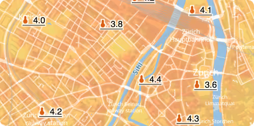
Heat Risk & Urban Vulnerability Mapping
We provide high-resolution urban maps and temperature projections to identify at-risk citizens and plan targeted cooling interventions, healthcare resource allocation, and public warnings.
Air Quality & Respiratory Risk Insights
Using local meteorological and climate data, we support forecasting and long-term planning around air quality, enabling better risk communication and urban health design.
Climate-Driven Health Emergency Preparedness
Our projections for heatwaves, flooding, and extreme weather help inform emergency response strategies, infrastructure readiness, and population safety plans in high-risk areas.
Safeguarding Urban Health Through Climate Insights
Localised urban health insights
We bridge the gap between climate science and urban planning by delivering data that supports real-world design, policy, and investment strategies.
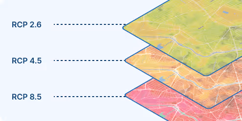
Scenario-based health-risk projections
We deliver insights across multiple climate futures (IPCC scenarios), enabling cities to prepare for best- and worst-case health outcomes.
Forecasts that trigger health responses
Our data can inform threshold-based alerts for heatwaves or extreme weather, supporting real-time decision-making and community safety.
Seamless Integration into Existing Systems
Integrate urban climate data and maps directly into existing warning apps, dashboards, and operational platforms to enhance situational awareness, automate workflows, and support faster, data-driven decision-making for cities and civil protection.
30+
Cities actively using meteoblue urban climate systems
100+
Urban Maps publicly deployed worldwide
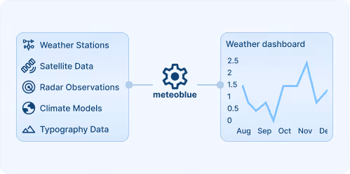
We started with a network of measuring stations to monitor the urban climate in Krefeld. Today, we have a comprehensive urban climate analysis from meteoblue and receive temperature forecasts that now also include heat warnings for heat-sensitive population groups.

Explore our Weather APIs
Premium Weather API
High-resolution forecasts, historical weather data, and interactive meteograms for any location worldwide.
Weather Maps API
80+ Dynamic weather map layers and tiles with global coverage.
City Climate API
Urban-scale climate data and indicators for heat, flood risk, and thermal comfort to support resilient city planning and analysis.
Weather Warnings API
Real-time severe weather alerts with customisable thresholds and geographic targeting for operational safety.
Climate Data API
Historical climate data and validated projections for risk assessment and ESG reporting.
Measurements API
Real-time and historical observations from weather stations around the globe for monitoring and validation.
Personalisierte Lösungen
Transform your smart city with cutting-edge weather insights.
