Dataset API
The meteoblue Dataset API provides direct access to large volumes of archived weather data, enabling efficient download of consistent datasets.


Explore Our Data: Variables, Models & Coverage
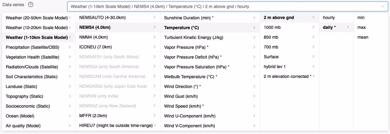
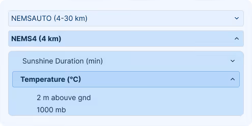
The meteoblue Dataset API grants access to the entire meteoblue weather data archive, which is composed of more than 100 weather variables gathered from over 50 data sources. This data can be composed and aggregated as desired via the API’s user interface.
Designed for Demanding Data Workflows
High-Volume Batch Delivery
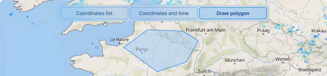
Retrieve large-scale weather datasets for the entirety of one or multiple regions in a single, efficient request. This eliminates the need for thousands of time-consuming single-point API calls, making it ideal for handling large geographic areas and long time periods.

Optimised for Machine Learning & AI
Accelerate your algorithm development and model training. The API provides fast access to complete, structured, high-resolution weather datasets, delivered in one request to simplify and speed up data ingestion for your AI and research workflows
Fully Customisable Data Selection
Request datasets adapted to your specific project requirements. Customise the time period and temporal resolution (hourly, daily, monthly aggregates), define the area and spatial resolution, and select the parameter groups you need.
Flexible Formats & Seamless Integration
Choose from a variety of file formats to receive data structured for optimal compatibility with your systems. The Dataset API is built for direct integration with modern data pipelines and cloud storage solutions, delivering analysis-ready data.
30+
Weather models provide a unique range of data
3,000+
Business customers from more than 100 countries around the globe
100+
Distinct weather variables to choose from
The meteoblue service has always been technically 100% reliable, and has always delivered top-quality forecasts. Working with meteoblue has been one of the best professional experiences I can think of, and we intend to continue in the future.

Success Stories
Solar-Log and meteoblue: A Partnership Shining Bright for a Sustainable Future
Sectors we work with
Energy
Optimise renewable generation and protect critical infrastructure with precise forecasts that prevent equipment failures and maximise output across all your energy assets.
Agriculture
Make smarter farming decisions with weather intelligence that protects crops, optimises field operations, and maximises yields while reducing resource waste.
Transport & Logistics
Keep fleets moving safely and efficiently by predicting road conditions, optimising routes around weather risks, and reducing delays from unexpected weather events.
Urban Resilience
Build cities prepared for tomorrow's climate by designing infrastructure that withstands future conditions and protecting critical systems from extreme weather.
Leisure
Deliver exceptional visitor experiences by planning events with confidence, ensuring guest safety, and optimising operations based on accurate weather forecasts.
Sustainability
Meet climate reporting requirements with regulatory-compliant data that demonstrates environmental progress and aligns business strategy with science-based targets.
Explore our Pricing Options
Flexible pricing plans designed for organizations from startups to enterprises. Explore the solution that fits your needs.

FAQ
The API grants access to over 100 weather variables sourced from more than 50 data models and 250,000 weather stations worldwide. Businesses can select parameter groups covering temperature, precipitation, wind, solar radiation, and more. With 30-plus numerical weather models available, organizations in energy, agriculture, and insurance gain the model diversity required for robust risk assessment, forecast validation, and multi-source ensemble analysis.
Businesses can define the exact time period, temporal resolution, geographic area, and spatial resolution for each dataset request. This granularity supports use cases ranging from site-specific agricultural risk modeling to regional energy grid planning. Custom data packages ensure that only relevant parameters are delivered, reducing processing overhead and optimising storage costs for organizations managing large-scale geospatial data infrastructure.
The API supports multiple file formats structured for direct compatibility with standard data engineering tools and cloud platforms. Format flexibility ensures seamless integration into existing ETL pipelines, business intelligence systems, and scientific computing environments. Organizations can ingest weather data without format conversion, reducing integration lead time and accelerating time-to-insight for operational and compliance-driven workflows.
The meteoblue Dataset API delivers large-scale weather datasets for entire regions in a single request, eliminating the need for thousands of individual API calls. This high-volume batch delivery approach is designed for organizations managing extensive geographic areas or multi-year historical periods. Data is returned in analysis-ready formats compatible with modern data pipelines and cloud storage architectures, reducing ingestion time and infrastructure costs for enterprise-level operations.