Climate Risk Assessment for Transport Corridors
Climate projections and risk indicators along road, rail, port and airport corridors let you identify vulnerable assets, compare routes and prioritise adaptation investment. Operational forecasts remain available for day-to-day routing.



Corridors cannot be rerouted overnight.
Roads, railways, ports and logistics hubs are built for decades, while the climate they operate in keeps shifting. Climate projections show how heat, heavy rainfall, flooding and wind exposure will develop along your routes, so investment and adaptation decisions can be made before disruption becomes routine.
800+
Climate Risk Reports sold
28
Climate hazard types
110+
Years of data (1990 to end of century)
Utilise climate data to enhance safety along the route
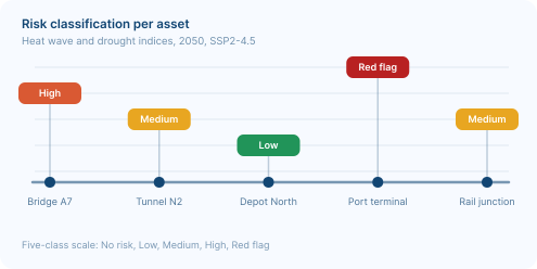
Identify the most exposed assets along the corridor
Infrastructure planning often lacks comparable climate information across a route. meteoblue delivers location-specific climate projections for any point along a corridor, so operators can rank bridges, tracks, terminals and depots by future heat, drought and precipitation stress and prioritise upgrades where exposure is highest.
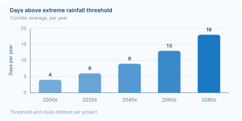
Anticipate flood exposure before it closes a route
Heavy rainfall and rising flood exposure threaten underpasses, junctions and logistics hubs. Climate projections show how precipitation extremes develop along your routes over coming decades, so drainage, reinforcement and rerouting decisions can be planned rather than improvised.
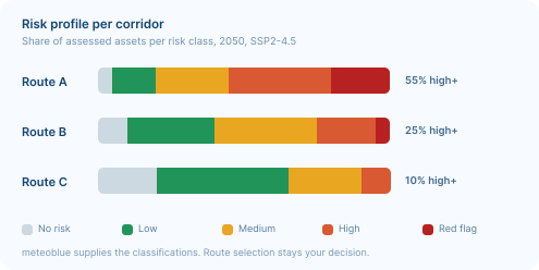
Compare the risk profile of competing corridors
Climate risk classifications for every assessed asset along competing routes show where exposure concentrates, so reinforcement budget can be justified and route decisions defended with traceable data rather than assumption.
What comes to my mind when I think of meteoblue is their customer-friendliness. The support team is always ready to help me with my inquiries and requests. And they do it with speed, with care, and with respect to my needs.

Our Experience in Transport & Logistics

Our Partnership with Microsoft Flight Simulator
Our Partnership with Microsoft Flight Simulator

Air Navigation - Air Navigation Pro and meteoblue: A Soaring Partnership in Aviation
Air Navigation Pro, used by more than 350,000 pilots, integrates meteoblue weather data for wind, clouds, visibility and radar.

Weathering the storm: The partnership between MarineTraffic and meteoblue
How MarineTraffic adds meteoblue weather data to its ship tracking platform to support safety, routing and planning at sea.
Climate products for corridor planning
Climate Risk Report
Standardised, site-specific assessments covering up to 28 climate hazards, with risk ratings for any point along a corridor worldwide.
Climate Data API
Climate indicators, risk classifications and raw variables across all RCP and SSP scenarios, ready to integrate into transport or supply chain platforms.
Plan resilient transport corridors with science-based climate risk data
