Real-Time Climate Intelligence for Data-Driven Cities
Combine IoT sensor networks with high-resolution modeling to map urban heat islands, validate adaptation measures, and engage citizens.


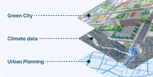
Integrate Urban Climate Intelligence Seamlessly into Digital Twins
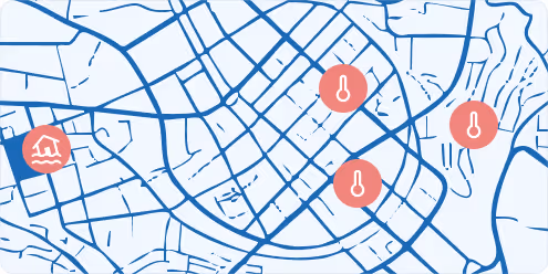
Urban Temperature Maps
Identify city-specific temperature extremes, heat islands, and vulnerable zones using high-resolution forecasts and future projections to guide cooling strategies and protect public health.
Flood Hazard Insights
Access rainfall intensity trends and flood-prone area assessments to inform stormwater planning, drainage design, and climate-resilient zoning policies.
IoT Sensor Network
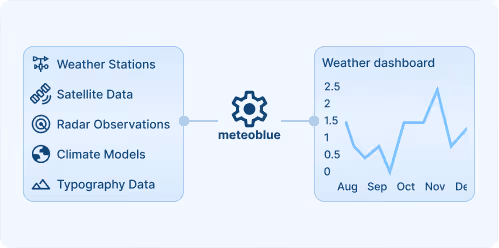
The IoT sensor network delivers continuous measurements of weather-related variables across dense urban grids to produce hyperlocal analyses and forecast to map urban climate patterns at building-level.
Smart Cities Starts with meteoblue Solutions
Hyperlocal forecasts and alerts
Hyperlocal forecasts and alerts combine dense sensor observations with high resolution models to provide street level predictions of various weather variables. Threshold based alerts activate when conditions exceed set limits, enabling rapid and risk aware decisions via API, email or dashboard.

Seamless integration in digital twins and smart city dashboards
Our APIs and data formats are compatible with smart city software, GIS systems, and planning dashboards.
Designed for decision-makers and local impact
We translate complex high-resolution climate data into ready-to-use outputs, empowering smart city decision makers to act.
Actionable and regulatory-aligned insights
Our climate indicators support funding applications, adaptation planning, and compliance with climate adaptation laws from different countries.
30+
Cities actively using meteoblue urban climate systems
100+
Urban Maps publicly deployed worldwide
150+
Stations in our largest city climate network
Three key features our customers value most
Highest-precision modeling
We use land-use regression (LUR) methods that scientists have identified as among the most accurate modeling approaches. This modeling approach is significantly more resource-efficient and environmentally friendly than complex and costly CFD models.
Integration & Forecasting
Historical measurements improve model accuracy.
Current measurements provide real-time validation.
Forecast models project hours and days ahead.
Climate scenarios show decades ahead. All integrated into one seamless system.
Dense IoT Measurement Network
Continuous monitoring of weather-related variables for getting microclimatic insights in real-time.
meteoblue is a well-suited partner with expertise in weather sensors and data management. Our partnership has helped us effectively communicate the value of measurements for reducing heat in urban areas to city planners, while the integration of IoT technology advances our goal of fostering climate-resilient and sustainable urban environments.
.avif)
Explore our Weather APIs
Premium Weather API
High-resolution forecasts, historical weather data, and interactive meteograms for any location worldwide.
City Climate API
Urban-scale climate data and indicators for heat, flood risk, and thermal comfort to support resilient city planning and analysis.
Weather Warnings API
Real-time severe weather alerts with customisable thresholds and geographic targeting for operational safety.
Climate Data API
Historical climate data and validated projections for risk assessment and ESG reporting.
Measurements API
Real-time and historical observations from weather stations around the globe for monitoring and validation.
Personalised solutions
Transform your smart city with cutting-edge weather insights.
