Weather Intelligence for Safer and More Efficient Aviation
Support aviation planning, routing, and operations with high-resolution, site-specific weather forecasts and dynamic weather maps tailored to airports, drone corridors, and flight paths worldwide.

High-Resolution Weather for Safe & Efficient Flight Operations
Precision Forecasting for Takeoff & Landing
High-resolution forecasts for wind, visibility, and precipitation help ground crews, ATC, and pilots prevent delays and hazards. Aviation-specific tools like METAR & TAF overlays, Stueve diagrams, and vertical cross-sections provide actionable near-surface and upper-air insights.
- Avoid disruptions from fog, crosswinds, or runway flooding
- Support pre-flight briefings and dispatch with real-time weather intelligence
Wind & Turbulence Profiles for Route Planning
Detailed vertical wind and turbulence forecasts - including cross-sections, trajectory simulations, and soundings - allow flight planners to identify safe and fuel-efficient routes.
- Reduce fuel use and emissions with dynamic routing
- Anticipate convective zones, high shear, and other in-flight hazards
Real-Time Alerts & Thermal Planning Tools
Early warnings for thunderstorms, icing, turbulence, and visibility risks help reduce operational downtime. Forecast layers such as thermal updraft strength or forward/backward trajectories offer critical insights for UAV, glider, and balloon operations.
- Increase UAV safety with thermal & air-mass insights
- Automate severe weather alerts via API integration
30+
Weather models provide a unique range of data
3,000+
Business customers from more than 100 countries around the globe
250,000+
Weather stations enable world’s highest precision
The Weather Intelligence that Air Operations Depend On
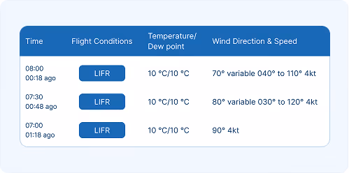
Low-Visibility Forecasting
Hourly-resolution forecasts help pilots, ground crews, and ATC anticipate visibility issues - critical for flight scheduling and runway safety.

Severe Weather Alerts
Receive real-time and severe risk warnings to support safe flight operations and reduce operational downtime.
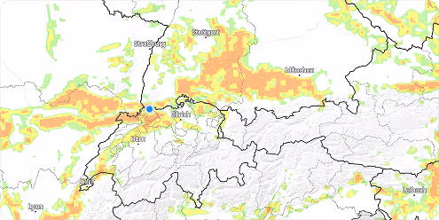
Wind & Turbulence Profiles
Access vertical profiles of wind speed and gusts to inform route planning and safety assessments.

Maps API for Real-Time Flight Weather
Integrate site-specific weather forecasts into your operational systems to support route planning, UAV missions, and airport operations.
Success Stories

Our Partnership with Microsoft Flight Simulator
Our Partnership with Microsoft Flight Simulator
Air Navigation - Air Navigation Pro and meteoblue: A Soaring Partnership in Aviation
A detailed look at how weather influences agricultural practices.

Weathering the storm: The partnership between MarineTraffic and meteoblue
An informative guide on hurricanes and their effects.
Explore our Weather APIs
Premium Weather API
High-resolution forecasts, historical weather data, and interactive meteograms for any location worldwide.
Dataset API
Bulk weather data transformations in NetCDF, CSV, and JSON formats for large-scale analysis and modeling.
Weather Warnings API
Real-time severe weather alerts with customisable thresholds and geographic targeting for operational safety.
Climate Data API
Historical climate data and validated projections for risk assessment and ESG reporting.
Measurements API
Real-time and historical observations from weather stations around the globe for monitoring and validation.
Personalised solutions
Transform your air operations with cutting-edge weather insights.
