Marine Weather Data for Confident Navigation
Support shipping operations, port logistics and offshore activities with high resolution marine weather forecasts and dynamic weather maps, including wind, waves, visibility and sea surface data, tailored for your route or location.


Seas Change Fast. Our Forecasts Keep You Ahead.
Weather Forecasting at Open Sea
Detailed forecasts for wave height, direction, period, and wind speed help reduce transit risk and improve vessel safety, even in the harshest ocean environments.
- Plan safe transits and protect cargo, crew, and equipment
- Minimise rerouting and fuel inefficiencies
Port Safety & Coastal Precision
Hyperlocal forecasts for wind, swell, fog, and precipitation support safer berthing, pilotage, and crane operations during critical port maneuvers.
- Anticipate disruptive weather near shorelines
- Reduce port downtime and improve vessel scheduling
Forecast-Driven Offshore Operations
High-resolution short-term forecasts help offshore teams time maintenance windows, personnel transfers, and inspections with confidence.
- Identify safe weather windows to reduce operational delays
- Protect offshore assets and ensure crew safety
30+
Weather models provide a unique range of data
3,000+
Business customers from more than 100 countries around the globe
250,000+
Weather stations enable world’s highest precision
The Forecasting Tools That Keep Maritime Operations on Course
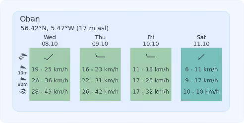
Marine Wind & Gust Forecasts
Access reliable forecasts for wind speed, gusts, and direction — critical for route planning, berthing maneuvers, and crane operations.
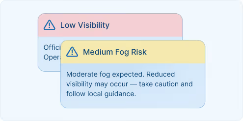
Fog & Visibility Alerts
Get accurate predictions of low visibility conditions to improve scheduling and reduce disruption in harbours and approach zones.
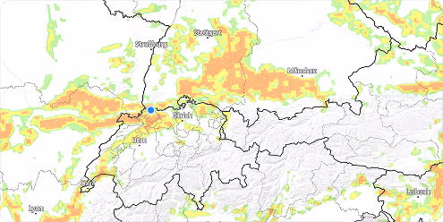
Wave & Swell Simulation
Monitor wave height, direction, and period across global and coastal zones. Reduce route risks and protect equipment during transit or mooring. Our Weather Maps help visualise marine wave patterns along your routes.

Short-Term & High-Frequency Updates
Receive forecast updates up to 144 times per day, with time steps down to 15 minutes — ideal for real-time decision-making in fast-changing conditions.
What comes to my mind when I think of meteoblue is their customer-friendliness. The support team is always ready to help me with my inquiries and requests. And they do it with speed, with care, and with respect to my needs.

Success Stories

Our Partnership with Microsoft Flight Simulator
Our Partnership with Microsoft Flight Simulator

Air Navigation - Air Navigation Pro and meteoblue: A Soaring Partnership in Aviation
A detailed look at how weather influences agricultural practices.

Weathering the storm: The partnership between MarineTraffic and meteoblue
An informative guide on hurricanes and their effects.
Explore our Weather APIs
Premium Weather API
High-resolution forecasts, historical weather data, and interactive meteograms for any location worldwide.
Dataset API
Bulk weather data transformations in NetCDF, CSV, and JSON formats for large-scale analysis and modeling.
Weather Warnings API
Real-time severe weather alerts with customisable thresholds and geographic targeting for operational safety.
Climate Data API
Historical climate data and validated projections for risk assessment and ESG reporting.
Measurements API
Real-time and historical observations from weather stations around the globe for monitoring and validation.
Personalised solutions
Transform your logistics with cutting-edge weather insights.
