Measure Effectiveness of Adaptation
Validate climate interventions with before/after measurement data. Prove to stakeholders that adaptation investments deliver real temperature reductions

If you can’t measure it, you can’t improve it.
To validate and quantify the impact, meteoblue installs sensors the measure the microclimate before and after or in parallel to the adaptation measure.
5+
Validated climate adaptation measures
10+
Successfully implemented urban planning concepts.
100+
Urban maps publicly available on meteoblue.com
Utilise our adaption verifications to assess the success of your project
Different Analysis Approaches
We apply multiple comparison methods to quantify adaptation effects. These include parallel measurements at adapted and non-adapted sites, as well as before–after studies at the same location.
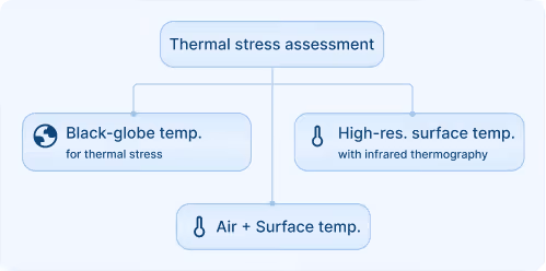
Comprehensive Measurement Techniques
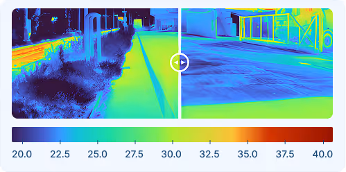
We use a range of measurement methods, including air and surface temperature monitoring, black-globe temperature measurements for thermal stress assessment, and high-resolution surface temperature mapping with infrared thermography.
Data-Based Reporting
We provide access to quality-controlled datasets for your documentation and further analysis. Based on these data, we deliver clear evaluation reports that quantify and communicate the effects of implemented adaptation measures.
We started with a network of measuring stations to monitor the urban climate in Krefeld. Today, we have a comprehensive urban climate analysis from meteoblue and receive temperature forecasts that now also include heat warnings for heat-sensitive population groups.

We offer custom-made solutions for urban resilience!
For Smart Cities
Integrate meteoblue APIs into Smart City Dashboards to deliver enriched environmental insights, predictive alerts, and contextual risk overlays.
For Urban Planning
Link sensor measurements with long-term projections to guide adaptive infrastructure planning, policy development, and urban heat mitigation.
For Residence Health
Combine open sensor data with high-resolution weather models for urban health, air quality, or microclimate research and impact studies.
For Infrastructure
Receive hyperlocal forecasts for road conditions, flooding, or heat-related stress to plan maintenance and adjust operations.
Personalised solutions
Transform your smart city with cutting-edge weather insights.
